30/05/11

lampung girl and the beauty of the beach

Lampung girl wearing Siger.Siger itself is a form that symbolizes the crown of greatness indigenous culture and livelihood of honor. Usually, Siger was always used by the bride's Lampung. That is, a symbol of Lampung is a symbol of feminine nature. In general, the symbol of the area around the archipelago are masculine. As in West Java, the symbol that was used is Kujang, which is the traditional weapon of Sundanese people. Or in Borneo, Saber is a symbol that is not different from West Java, which symbolize the patriotic qualities of resilience and defensive territory.

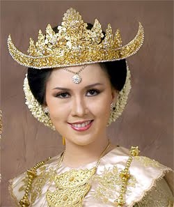
Encouraged a sense of
to curious, I continue to seek information about this Siger. A folk story I got from an Internet site, which tells of a magic Siger. In Marga Sekampung, East Lampung there is a story passed down through generations which is still in the trust as a Living Legend.
Once upon a time when residents will be holding events such as weddings or indigenous Lampung Cakak Pepadun (a ceremony Lampung). Community borrow or use Gold Siger of faerie through a place in one community garden. Gardens residents whose presence was supernatural, a slum community of Lampung at the time is earlier than that time. But in fact in this slum dwellers lost their village. But people can still relate to the lost village residents by borrowing Siger who used to be used in these traditional activities. But because greed residents who have to cheat after using Siger was not in the back again to the magical village again, so that the existence of supernatural Siger was lost some where. But in the magical village community was still often heard the voices of the inhabitants of the faerie. Like the typical sound of music kolintang Lampung on certain days.


Lampung Marina Beach has beautiful scenery with rocks that form varies. According to folklore, there is a rock called Stone Center of the Earth is where Prince Cindar receive visitors.


Tanjung Setia which is 60 km from Liwa, the capital of West Lampung, with high waves to shore.
for surfers (surfing) all over the universe, Tanjung Setia crowned the third best beach waves surfing dunia.Bagi, Tanjung Setia is a hidden paradise (the secret paradise).
This area is famous for its waves and the height of one of the world's top beach waves surfing so the target countries. Coastal wave heights facing the Indian Ocean, could reach seven feet tall with a wavelength of 200 meters south of the season (May-October).


Way Hawang Beach is a beach that has white sand and a bay so the water was calm and coastal tourism net Object Way is located in the district Hawang kaur.antara Bintuhan with Merpas.
Besides the beautiful beaches here are stone objects jung is a rock shaped like a ship / boat Beach district hawang way maje Kaur district.
According to the myth of this stone came from a ship, this happens because of the curse of the bitter tongue. At that time there is a ship that was looking for fish, but there is a father (the bitter tongue) that are running around the beach.
He asked the fire on the ship owner that he called-Mangil but such is not ignored, not necessarily because the ship ignored but the distance was far enough from shore so as not to be heard by the owner of the vessel. Sipahit tongue cursing at her wrath and the ship was turned to stone, then the ship was changed into stone. when viewed form the rock very similar to a ship / boat.very fit for a vacation with family at the weekend

 
Source: www.pariwisatabengkulu.com

Lampung Kiluan Gulf Coast is located at 103 040 'E to 105 050' E and 03 045 '06 045 LS to "LS with a long coastline of ± 1105 km (including some islands) is divided into 4 territorial waters, including waters of the West Coast (± 210 km), Gulf Semaka (± 200 km), Lampung Bay and the Strait of Sunda (± 160 km), and East Coast (± 270 km).
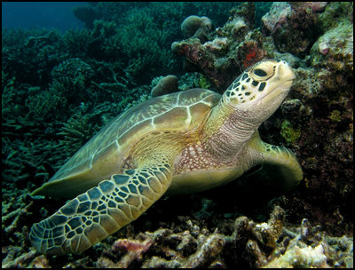
Kiluan Bay in the Gulf region and is largely Semaka Tanggamus District area, has a coastal area up to the hills. For certain circles, this bay has been known for a long time because in this region can be found distribution of dolphins in large numbers and is a very potential fishing area (Fishing Week I 2006 and II 2007) to be developed into tourist fishing. Also, in this area can be found breeding Hawksbill (DKP Program Lampung in 2007) because in this region is a place of spawning (Spawning ground) various species of sea turtles, such as the hawksbill.
In addition to the diversity of natural beauty, Kiluan Bay has a diversity of people from several tribes, such as the Sundanese, Javanese, Balinese, Bugis to Lampung, so it is not surprising if people have customs, religions, and different languages​​. All the general population is immigrants, although there is a small part of the original inhabitants who in this population from birth to adulthood in the vicinity of the Gulf region Kiluan. However, all can live and coexist in harmony.


29/05/11

Prediction of major earthquake in western Indonesia Lampung sumatra

source, Liputan 6.com
Australian plate collision zone, and Eurasian plates that are dynamic and continue to occur could cause the energy collected will be released in due course. If so, Lampung Province is expected to become the next big quake hit. As disclosed earthquake experts Bandung Institute of Technology, Professor Doctor of Sri Widiyantoro, recently.

Sri Widiyantoro explains, an earthquake in Padang, West Sumatra and Jambi on Wednesday and Thursday causing blood to lock in the Mentawai Islands earthquake becomes weak. As a result, expected to be an earthquake measuring 8.9 Richter is not known when. If the energy is released at once, then in the coastal areas of Padang and Bengkulu will ambalas 1.5 meters.

Whereas if an earthquake ripped the sea floor, it will cause tsunamis as high as 15 meters. Even storm tsunami that would reach the coast of West Sumatra and Jambi in 10 minutes.


Anticipation Earthquake - Tsunami, Head Mandatory On-site
 Liwa - All subdistrict in West Lampung forbidden to leave their posts, related to the possible impact of the earthquake and tsunami in West Sumatra, a few days ago.

West Lampung Sekkab say If you want to leave their areas of responsibility, district must first ask permission from the Regent and the district secretary who remain at their posts.

Where the earthquake that occurred in the Mentawai Islands have earthquake fault line to the West Coast. This resulted in West Lampung as one of the areas prone to earthquake disaster.

Earlier, West Lampung regency prompted the threat of earthquake and tsunami alert since the area is a region through which the crossing point of the earthquake. From time to time underlayer may occur such natural disasters.

To that end, West Lampung regency are encouraged to continue to socialize and continuous simulation of the impact of the earthquake and tsunami to the public.

Head of the Meteorology and Geophysics Kotabumi Chrismanto said that despite the unpredictable earthquake, quake always occurs at a crossing point earthquake that formed beneath the earth's surface.

Within the last 10 months, his record six times in the underlayer earthquakes, with intensity of 5 to 5.5 on the Richter Scale (SR). Earthquake average depth is 10-30 km below sea level.

Underlayer region is indeed one area in Lampung Province is quite prone to earthquakes, so it can be said a normal phenomenon.

27/05/11

It's Got Potential JakartaEarthquake 8.7 SR

JAKARTA, Staff of the Special Presidential Division of Social Assistance and Disaster Andi Arief, Sunday (5/15/2011), states, Jakarta has the potential magnitude 8.7 earthquake (SR). Potential earthquake, which was not a new issue, derived from seismic activity in the Sunda Strait region.
In response, researchers from the Center for Earthquake Research Geotechnology Indonesian Institute of Sciences (LIPI), Danny Hilman Natawijaya, said, "The potential exists. Its strength can be as they say, 8.7 on the Richter scale. But it still needs to be assessed, whether this can be less than that or even more. "
Danny said, the potential strength of an earthquake can be estimated by looking at the dimensions of the subduction zone. "The strength of the quake, right, is directly proportional to the source of the earthquake, subduction zone dimensions. From there we could transfer to a particular formula, so get a potential earthquake," Danny said when contacted on Tuesday (17/05/2011).
Potential earthquakes on the Sunda Strait could occur because the region is above the subduction zone of the Indo-Australian Plate and the Eurasian and oblique subduction transition zone in western Sumatra subduction upright in the south of Java. Earthquakes can be triggered by the release of energy from the Indo-Australian plate movement to the north with a speed of 6 cm / year.
According to the record so far, Danny said, small-magnitude earthquake in fact often occur in the Sunda Strait region, but not with large magnitude earthquake. He did not dismiss the possibility that a large earthquake could occur due to seismic activity in this region even though the timing is not predictable.
Danny said, you need to do now is seriousness in the record. According to him, the research potential of earthquakes in the Sunda Strait are still minimal. In fact, when compared with the Sumatra earthquake research, research in the Sunda Strait is not nothing.
Related to this earthquake potential, Danny said that Jakarta needs to do a precaution. "This is because in Jakarta, is not it, a lot of assets and technology. For example if the cyber center building was damaged, this will affect the whole of Indonesia. Not to mention, for example, banking and other sectors."
Danny adds the need for preparation at the community level. "The upgrading of the public also needs. For example, in Padang, right, has never happened, the people invited are ready. But how in Jakarta? It should also be done." In addition, earthquake-resistant buildings and evacuation system in the building when an earthquake happens also to be addressed.
So far a large earthquake records in Jakarta is still minimal. "There are notes in the book Hanna (Hanna-Willard A Tale of Jakarta) that large earthquakes have occurred in 1699 which resulted in severe damage. However, it is not known whether the quake originated from the Sunda Strait region," said Danny.Share1299.


source kompas.com

26/05/11

Ring Story Nyi Roro Kidul, Myth or Fact?


Nyi Roro Kidul, Myth or Fact?

Nyi Roro Kidul is no doubt about his fame. Indonesia is one of the legends can make us cringe during a visit to South Beach or view a painting that depicts the Queen was riding a horse-drawn carriage on the roll of waves. Very mystical!

Apparently, the legend is not just a myth, you know. In fact, a researcher from the Indonesian Institute of Sciences (LIPI), DR. Eko Yulianto connecting the tsunami with the legend of Nyi Roro Kidul. It has even been discussed at the paranormal congress in Paris in the 1980's, you know. South Coast region which 'controlled' by Nyi Roro Kidul Indonesia dealing directly with the Indian currency is a subduction zone (collision) Earth's plates.

Well, believe not believe it ... but it does not hurt us to respect the legends and beliefs that flourished in the community? As some of the things below:

     Room number 33 at the Hotel Queen of the South, Parangtritis closed to the public because of "dedicated" to the Queen.

     The king of Yogyakarta and Solo, always do the traditional harbor once a year in the month of Sura. The king sent offerings to the Sea Selaran as offerings to Nyi Roro Kidul.

     Dance Bedaya sexual intercourse and Bedaya Semang in Kraton Yogyakarta and Surakarta Palace Bedaya Ketawang held in honor of Nyi Roro Kidul once a year. Nine dancers dressed in traditional Javanese wedding. They say the ten dancers are Koro Kidul Nyi who came to marry the King.

There are two rooms in the hotel Grand Bali Beach, Bali, supposedly inhabited by Nyi Roro Kidul, the cottage number and room number 327 2401. These rooms are done up until now maintained neat and decorated with green special favorite of the Queen


Designed By Blogs Gone Wild!